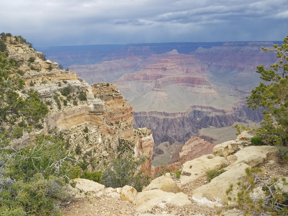
The Grand Canyon is one of the first geological landscapes in the world that curves into a series of flat plateaus, with an average of one mile deep and ten miles across. Geologically, the Grand Canyon is classified as a young one because of its curvature in the last six million years by the Colorado River, together with the river’s tributaries (Karlstrom et al., 2017). The river waters, mainly sourced by snow, melt in the Rocky Mountains and used boulders, sand, and cobbles in carving a canyon. The Canyon is located in the northern part of Arizona and presently a tourist site.
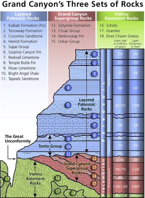
The canyon formation and sculpting of the present landscape by forces of erosion are considered a chapter in the Grand Canyon’s geologic evolution. Three sets of rocks have been discovered in the Canyon walls, resulting from carving. They include Paleozoic rocks from the horizontal layer of sedimentary rocks that make up the upper strata. These Meso-Neoprotezoic sedimentary rocks, according to Hill et al. (2016), are exposed to faulty blocks and preserved in the eastern Canyon. Most of the metamorphic suites and igneous are usually located at a depth of the Grand Canyon. The three rocks in the canyon wall record the continental crust’s formation and modification of the region.
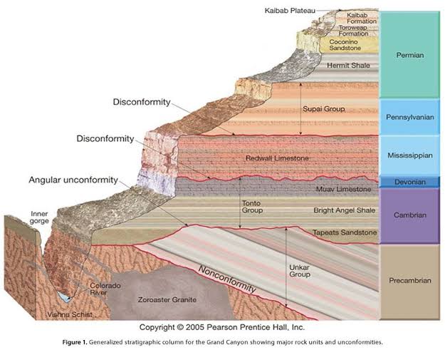
The Eastern Grand Canyon is unique because it has almost all the Canyon rock units. It is also the only canyon part where the Chuar Group Strata and the Sixtymile Formation are located. According to Karlstrom et al. (2017), canyons have two steep and deeper sides, forming a vertical cliff face. The canyons are formed by weathering and erosion, especially during winter seasons.
The seeping of water into cracked rocks causes water to freeze and expand, turning into ice. Once the water turns into ice, it enlarges the crack and erodes the stone’s bits as the process continues. Therefore, the continuous expansion of rocks caused by freezing results in crumbling, and the Canyon becomes wider at the top, unlike at the bottom (Karlstrom et al., 2017).
The history of the Grand Canyon runs deeper as the first encounter with the 277 miles long Canyon traces to over 12,000 years ago. The meeting resulted from the migration and spread of American people across the continent. According to Lathrop (2018), by the 16th century, many explorers from Spain had already begun passing through the canyon. In 1869, a veteran of the Civil War named John Powel, together with nine men, commenced a boating expedition at River Colorado. Reports from his trip became fundamental in cementing the reputation of the Grand Canyon as a natural wonder and national icon (Tiedeman, 2016).
Formation of the Grand Canyon by tectonic lift
The story of the Grand Canyon started close to two billion years back when two plates of the crust collided. The joining of these two plates caused rowing of volcanic islands, later smashing together and merging to form a single plate (Hill et al., 2016). Under extreme pressure and heat, rocks started transforming into darker colored ‘basement’ rocks, which are still visible at the bottom of the Canyon. Hill et al. (2016) further states that a.1.8 billion-year-old rock named Elves Chasm gneiss also exists in the Canyon as id the oldest known in the Canyon.
According to Žáček et al. (2017), canyons can form through tectonic uplifts, also known as tectonic activity. Tectonic activity refers to the tectonic plates’ movement causing geologic activity, including earthquakes and volcanic eruptions. The tectonic plates compose of oceanic lithosphere and continental lithosphere, each with a unique kind of crust. Plates move under one another in a convergent boundary, or a plate may also move under another, carrying the lower one into the earth’s mantle.
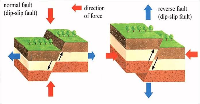
The movement of tectonic plates during the formation of a Canyon results from the lithosphere’s greater mechanical strength, which subdues the asthenosphere. Tectonic uplifts in the earth’s crust cause it to rise higher than the surrounding area and create mountains and plateaus. Thus, rivers and masses of ice moving slowly over the land also cut through higher areas forming deep canyons.
The Grand Canon’s uppermost layer, also known as the Kaibab Limestone, was formed at the ocean bottom. Žáček et al. (2017) state that in the present day, the layer elevates up to 9,000 feet. The Colorado plateau’s uplift was a fundamental step in forming the Grand Canyon; the plate tectonic actions pushed the rocks higher and flat, leading to creation a table through which the Colorado River passed. Karlstrom et al. (2017) argue that the Colorado plateau’s uplifting seems puzzling because, with uplifts, geologists anticipate rocks deformation. The Rocky Mountains’ rock composition was dramatically deformed and crunched in the uplift process; however, there was no significant rock alteration on the plateau. Instead, they uplifted and flattened.
The Grand Canyon is a feature of the late Cenozoic, which is a trait of renewed erosion. The dry climate of the region facilitates the widening of the Canyon. Violent storms occasionally send flash floods to gouge down the narrower side of the Canyon. However, according to Lathrop (2018), lack of steady moisture has formed a firm landscape of mostly naked rocks. Some rocks in the Grand Canyon, such as Redwall Limestone and Coconino Sandstone, can resist erosion, and harder, and have eroded into bold cliffs.
The Grand Canyon’s softer layers melt into slopes, for instance, the Tonto Platform and Hermit Shale (Esplanade). The most ancient crystalline rocks have been chiseled into rugged cliffs of the Granite Gorge. According to Hill et al.(2016), the Grand Canyon wall is formed by 40 identified rock layers. The layers have attracted students and researchers of earth history since the mid 18TH century.
Most of the Canyon’s rock layers are usually exposed through its 277-mile length, hence provide an opportunity for detailed and comprehensive studies of changes in the environment in past geology.
Most canyons usually compare to silent journals of places’ history over a long period. The study of exposed rock layers in canyon walls enables researchers to learn about climate change. The layers’ analysis also allows scientists to live in certain times, such as understanding how they would transform in the future. The study of rock layers in the Columbia River Gorge discovered the oldest rocks, which can be traced back to 17 million years ago. Geologists discovered basalt from the hardened lava and established that the rocks resulted from a volcanic eruption and lava spillage on to land (Karlstrom et al., 2017).
In conclusion, the Grand Canyon is a river valley located in the Colorado plateau. The Canyon reveals the elevated Paleozoic and Proterozoic strata or layers. As stated in this paper, the Great Canyon resulted from tectonic uplifts and weathering. The Grand Canyon National Park is a tourist attraction site because of its beautiful scenery and over 1,700 species of plants, fungi, lichen, and moss.
References
Alchetron. (2017). Tectonic uplift—Alchetron, The Free Social Encyclopedia. Alchetron.Com. Web.
CK-12 Foundation. (2020). Principle of Horizontality. Web.
Hill, C. A., Polyak, V. J., Asmerom, Y., & P. Provencio, P. (2016). Constraints on a Late Cretaceous uplift, denudation, and incision of the Grand Canyon region, southwestern Colorado Plateau, USA, from U-Pb dating of lacustrine limestone. Tectonics, 35(4), 896–906.
Karlstrom, K. E., Crossey, L. J., Embid, E., Crow, R., Heizler, M., Hereford, R., Beard, L. S., Ricketts, J. W., Cather, S., & Kelley, S. (2017). Cenozoic incision history of the Little Colorado River: Its role in carving Grand Canyon and onset of rapid incision in the past ca. 2 Ma in the Colorado River System. Geosphere, 13(1), 49–81.
Lathrop, E. C. (2018). Understanding the Late Mesoproterozoic Earth System from the Oldest Strata in Grand Canyon: C-Isotope Stratigraphy and Facies Analysis of the 1254 Ma Bass Formation, Grand Canyon Supergroup, AZ., USA. All Graduate Theses and Dissertations. 7046.
Pinterest. (2020). Nice diagram of Grand Canyon strata. Web.
Tiedeman, K. (2016). Tectonic evolution of the Colorado plateau and Grand Canyon region: 500 million years of movement | Education at the Center for Watershed Sciences. Ucdavis.Edu. Web.
U.S. Geological Survey. (2020). USGS.gov | Science for a changing world. Web.
Žáček, V., Hradeckỳ, P., Kycl, P., Ševčík, J., Novotnỳ, R., & Baroň, I. (2017). The Somoto grand canyon (Nicaragua)—a volcanic geoheritage site one decade after discovery: From field geological mapping to the promotion of a geopark. Geoheritage, 9(3), 299–309.