Introduction
The San Andreas Fault is definitely one of the most significant and infamous geological formations in the United States landscape. Stretching for approximately 800 miles and having a depth of 10 miles, it is one of the biggest known networks of faults on land that mark the boundary between the Pacific and North American tectonic plates. The location is one of the most well-studied geological formations, but much is still unknown. This paper will seek to explore the San Andreas Fault, including its physical characteristics, origin and formation, its connection with earthquakes, and future research and events associated with the fault.
Geographic and Physical Description
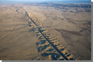
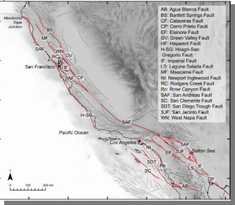
A mentioned earlier, the San Andreas Fault stretches across California for 800 miles. It is one of the longest geological structure over land in the Earth. The San Andreas Fault Zone (SAFZ) is the primary boundary between Pacific and North American tectonic plates. The tectonic plates move approximately 2 inches a year. The zone is typically divided into Northern and Southern. Northern California includes the San Andreas, as well as Hayward, Calaveras, and other faults. To the north, extensions of the fault are dramatic, reaching 400 miles under the sea, merging into the Murray Fracture Zone on the deep ocean floor. The Southern zone is wide, encompassing the San Andreas, the San Jacinto and other faults in the Los Angeles region. In the south, the fault continues to follow the exais of the Gulf of California for more than 1,000 miles. Over the majority of the San Andreas length, a linear trough can be seen from the air, although more subtle on the ground. There is a linear arrangement of bays, valleys, and lakes due to the trough. The fault zone can be identified by distinct landforms such as long straight encampments, narrow ridges, and undrained ponds in the blocks of the zone (Schulz and Wallace).
Most of the faults in the SAFZ are considered mature as they have accumulated tens of miles of displacement, putting the network within totals common for transform faults around the world. The progress of the San Andreas Fault in Southern California impacts a significant piece of the continental crust, because the active fault moved inward throughout the Miocene era. In the central and northern California, the fault network is almost 100km wide, established broadly by the offset San Joaquin and La Honda basins. Plate boundary faults east of the primary San Andreas Fault line are discontinuous as slip is transferred across faults, both releasing and restraining bends and step-overs (Scharer and Streig 252).
Origin and History of Exploration
The San Andreas fault is believed to have formed in the mid Cenozoic era approximately 30 million years ago. At this point, the Pacific Plate encountered the North American plate as the Farallon oceanic plate disappeared underneath North America at a subduction zone. This structure resulted in the Pacific and North American plates sliding past each other rather than crashing, creating a boundary known as strike-slip fault. Geologists estimate displacement along the fault is approximately 350 miles since original formation (Oskin). A crustal fracture zone was formed with a right-later offset. Parts of the North American Plate were added to the Pacific Plate. The fault system comprise multiple strands as can be seen in the image above. One fault may creep through geological history and then become locked for thousands of years while the motion is transferred to nearby or newly formed strands (“San Andreas Fault: An Overview”).
On April 18, 1906, one of the worst and infamous earthquakes in the Western world occurred in the San Francisco Bay Area. At this point, the Reyes Peninsula moved northwest almost 20 feet, while San Francisco was crippled and devastated by fires. At the time, people were aware of earthquakes, but there was little knowledge regarding their origin or mechanism. After the 1906 earthquake, a U.C. Berkley scientist named Andrew Lawson assembled a team of geologists to study the event and the changing landscape. They published what became known as the Lawson Report which identified the fault and labeled as the cause of all the regional earthquakes. The commissioned report established for the first time in academia what occurs during a major seismic displacement, like the one in 1906. He named the fault San Andreas after a local San Andreas lake (Ashworth, n.d.). Eventually, a 1953 paper by Mason Hill and Thomas Dibble proposed a radical idea that the fault resulted in lateral movement of hundreds of miles, but it is only in modern times, with the availability of technology could the theory of plate tectonics be confirmed.
Earthquakes
Earthquakes are defined as sudden, violent, and hazardous shaking of the ground that occur due to release of energy from the planet’s crust. Tectonic plates are consistently moving, but they may become stuck at edges due to friction at faults such as the San Andreas one. Whenever stress overcomes the fiction, energy is released through seismic waves which travel through the crust creating the shaking. The Pacific Plate moves northwest past the North American plate at a rate of 2 inches per year. Typically, parts of the fault system adapt to the movement through a phenomenon known as ‘creep’, which produces multiple tiny shocks which are only registered by instruments with a few moderate low-magnitude tremors. However, creep must occur constantly, and in areas where it is not consistent, stain builds up over decades until it finally releases through more severe earthquakes (“What Is an Earthqauke?”).
The landscape is highly fractured in the Southwestern United States, resulting in a series of cracks and faults, the biggest one of which is the San Andreas fault. There are also the Ridgecrest and the ancient Garlock faults, connected to San Andreas. They are interconnected, as geologists believe that recent 2019 earthquakes at Ridgecrest, increase the probability of a Garlock earthquake (it is important to remember that after each major earthquake aftershocks can continue for months, ranging up to thousands). Although the probability remains low at 2.3%, a 7.7 or higher magnitude earthquake on the Garlock fault will most likely trigger the San Andreas fault, stemming earthquakes along it (Wei-Haas).
A recent research from the University of Southern California took a different approach of examining earthquakes along the San Andreas fault. The majority of seismic activity in California originates in the first 10 miles of the crust. However, some tremors on the San Andreas fault can be located much deeper and are still being studied. Notably, after a significant earthquake, tectonic plates that meet at the fault boundary have a relatively peaceful phase of gliding past each other with little disturbance. However, eventually, the motion across granite and quarts in the bedrock generates heat due to friction. With heat increasing past 650 degrees Fahrenheit, rocks begin to morph into fluidlike forms, allowing them to slide with ease, generating more friction, thus more heat and eventually the sliding creates an earthquake (Wang & Barbot). This is an innovate perspective on earthquakes that are typically examined from the top layers of the crust that potentially have an impact on the deeper levels, while this study suggests it may be the other way around. Recognizing this seismic movement may be vital to learning to predict earthquakes which is virtually impossible at this point in time, as discussed in the next section.
Future Status
Scientists have been gathering key data along major paleoseismic sites along the San Andreas Fault Zone (SAFZ), generating a timeline of past earthquakes going back centuries. One of the biggest concerns for the future is that for multiple sites on the San Andreas Fault, the average time between large earthquakes is currently exceeded, with the popular term in popular culture and scientific community, that the region is ‘overdue’ for a large event. The paleoseismic data can be beneficial in establishing timelines, but it does not serve as a predictor since earthquakes do not adhere to specific timelines necessary nor does the scientific community know enough about earthquakes to determine when and where the next one would occur (Wald et al.).
A major concern is that there has not been a major release of geological stress in the southern portion of the SAFZ since the mid-19th century. Both Pacific and North American tectonic plates are moving north, but the Pacific plate is moving faster, meaning that stress is consistently building up. While major earthquakes occurred in 1906 in San Francisco and 1989 Loma Prieta, these were in the north of California, leaving the southern portion of the SAFZ to continue building up stress. The minimal amount of slip deficit is approximately 7-10 meters, which is the maximum co-seismic offset ever recorded. The strain accumulation with respect to geologically mapped fault traces indicates that SAF is nearing the end of interseismic recurrence (Fialko 968). Therefore, while predictions are difficult, many scientists expect a major release in the next 30 years if not sooner, generating an extremely high-magnitude and destructive earthquake in the region, labeled the ‘Big One.’ The U.S. Geological Survey modeled an earthquake in southern SAFZ at 7.8 magnitude with slippage of 2-7 meters, suggesting $33 billion in infrastructure damage and potentially an 1800 death toll, with older buildings in the region experiencing most impacts as well as damage from potential fires due to disrupted gas pipelines (Blackett).
As discussed earlier, the deep faults that generate earthquakes are notoriously complex networks of cracks and chasms which makes it difficult to study and predict. Faults also interaction and stresses in one fault can cause a sequence of earthquakes in other parts. Geologists can create models based on known seismic data from past and present to visualize the fractures in the fault zone and model the motion of stress along the fault network. In other words, it allows to model potential areas of effect and destruction, and at most predict the probability of an even occurring which is far from an exact science (Wei-Haas). Predictions have to based on some sort of precursors or signals. So far scientists have considered multiple approaches ranging from electromagnetic activity to geochemical changes in groundwater and radon gas concentrations. Seismologists have not yet found reliable precursors, if such exist, to predicting large earthquakes. The most promising approaches rely on monitoring electromagnetic activity and forecasting appropriately.
Metropolitan areas such as San Francisco and Los Angeles are built on plate boundaries, exposed to significant risk due to large earthquakes. Due to only the recent study of geology by complex instruments, the records are too short to have meaningful data to forecast future earthquakes, and it is likely that decades of paleoseismic, geodetic, and seismological studies are necessary to understand fault behavior. The challenge going forward would be to combine long-term behavior with short-term geodetic studies in a way that current hazards from the faults are competently characterized (Scharer and Streig 265).
Conclusion
The San Andreas Fault is undoubtedly on the most famous geological formations on Earth. Stretching across 800 miles California in a complicated network of faults and schisms, the San Andreas Fault marks the border between the Pacific and North American tectonic plates. Being over 30 million years old, it has only been extensively studied in the last century, continuously providing geologists and seismologists with insights about the structure of the planet’s core and origins of earthquakes. Unfortunately, due to the he nature of the tectonic movement, the fault is responsible for the region’s significant seismic activity. There are expectations that a major earthquake will strike the SAFZ in the coming decades, but scientists are actively studying the fault and modeling various possibilities in the attempts to be able to predict earthquakes which is currently virtually impossible until the moment it, and it continues to remain a prominent element in the Earth’s geological structure.
Works Cited
Ashworth Jr., William B. ” Scientist of the Day – Andrew Cowper Lawson.” Linda Hall Library, 2019, Web.
Blackett, Matthew. “The San Andreas Fault Is About to Crack – Here’s What Will Happen When It Does.” The Conversation, 2016, Web.
Fialko, Yuri. “Interseismic Strain Accumulation and the Earthquake Potential on the Southern San Andreas Fault System.” Nature, vol. 441, no. 7096, 2006, pp. 968–971.
Oskin, Becky. “San Andreas Fault Facts.” LiveScience, 2015, Web.
“San Andreas Fault: An Overview” USGS, 2005, Web.
Scharer, Katherine, and Ashley Streig. “The San Andreas Fault System: Complexities Along a Major Transform Fault System and Relation to Earthquake Hazards.” Transform Plate Boundaries and Fracture Zones, 2019, pp. 249–269.
Schulz, Sandra S., and Robert E. Wallace. “The San Andreas Fault.” USGS, 2020. Web.
Wai-Haas, Maya. “Recent California Earthquakes May Have Made the Big One More Likely.” National Geographic, 2020, Web.
Wald, Lisa, et al. “Back to the Future on the San Andreas Fault.” USGS, 2017, Web.
Wang, Lifeng, and Sylvain Barbot. “Excitation of San Andreas Tremors by Thermal Instabilities below the Seismogenic Zone.” Science Advances, vol. 6, no. 36, 2020. Web.
“What Is An Earthquake And What Causes Them To Happen?” USGS, Web.