Introduction
The character of Orkney’s incised stonework is a topic that has been seriously under-researched and all but ignored by the archaeological community. This paper is a commencement rather than a conclusion intended to introduce the abstract inscriptions carved into the Orcadian landscape during the Neolithic and Bronze Ages. It is not an attempt to interpret the artwork or discover its origins or occupation in the landscape. The nature of this study involved examining Orcadian prehistoric stone decoration to establish its character as either unique or as part of a larger prehistoric community network.
To achieve this goal, three primary questions had to be answered:
- is there any rock art in Orkney?
- are there examples of rock art in Orkney’s burial chambers similar to inscriptions often found in other chambers around the U.K. and Ireland?
- are there examples of rock art in Orkney unique to the isles?
The first question seems fairly straightforward; however, until recently, many archaeologists thought that Orkney, like much of Scotland, was lacking in rock art examples. The University of Reading even acknowledges this supposed deficiency on their Archaeology website when they mention that, “Now it seems that the absence of ‘megalithic art’ from Orkney was more apparent than real.” This quote relates to recent research undertaken by Richard Bradley and Tim Phillips in the summer of 2005 when they examined all the well-preserved tombs in Orkney for examples of Megalithic art. The answer to the first question will be accompanied by a detailed list and photographs or drawings of the known examples of Orkney’s decorated stone.
The second question, then, will compare Orkney’s stone art to other well-known rock art regions around the U.K. and Ireland, such as Ilkley Moor, England, Kilmartin, Scotland and Boyne Valley, Ireland. If a connection can be made to these regions through shared artwork, then it is reasonable to expect some shared cultural beliefs or trade. Much of Orkney’s prehistoric artwork is expected to parallel what has already been discovered in other areas. Nevertheless, by answering question three, this research confirms that although Orkney was connected to a larger global community, it still exists retained its own unique identity and perspective.
Finding answers to these questions required researching the Orkney SMR, the NSMR and the National Museum of Scotland. Extensive travel throughout the Orkney isles was also needed. In addition to the research mentioned above methods, past works carried out by Elizabeth Shee Twohig, Stan Beckenshall, George Eogan and Richard Bradley, among others, were also consulted. Personal communications with Richard Bradley and J.R. Hunter have proved both enlightening and supportive, and their comments will appear through the work.
The scope of this research was limited to the Neolithic and Bronze Ages in Orkney’s history. Landscape archaeology of prehistoric Britain is principally archaeology of settled communities. Only recently have the Paleolithic and Mesolithic periods’ ‘archaeology of mobility’ (Infante, Vaquero and Criado 1992) received much attention. Due to their very nature of being mobile and owing to their manufacture of perishable artwork, these periods have been excluded from this research. Similarly, ‘rock art tends to disappear by the period of agricultural intensification during the Later Bronze Age and Iron Age.” (Bradley: 7, 1997) Naturally, there are a few exceptions to this. Still, for the most part, when the organisation of a wholly agricultural economy and a system of permanent settlement comes to light, it sees the world differently. Therefore, any periods after the middle Bronze Age has also been excluded from this study.
Archaeological Findings and the Study of Rock Art
It was not clear what the University of Reading meant when it claimed that tombs in Scotland or Wales had “decoration is rare or absent” (SHES, 2006). It went on to describe one with “contained the pecked decoration so typical of the Boyne Valley” with others having “similar motifs, incised into the stonework with a fine point.” Aside from comparing them with Skara Brae, it claimed that the motifs resemble pottery designs and other portable artefacts around 3000 BC.
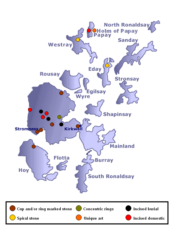
While the above premise may seem discouraging, this paper will proceed to its original goal of describing the prehistoric stone decoration at Orkney. Below is a Stone Map showing archaeological findings of various designs of rock art in and around Orkney.
Problems with describing and recording artefact decorations prevailed during the early archaeological stages among many sites of historical relevance. Philology was displaced as rock art research received less attention to a discipline increasingly focused on the techniques of stratigraphic excavation (Whitley and Loendorf, 1994, pp xi-xii). Whitley and Loendorf (1994) noted that archaeology during the last half of the nineteenth century followed the positivist program incorporating geological principles of stratigraphy, uniformitarianism, Darwinian biological evolutionism, and cultural evolutionism.
For quite some time, ethnohistoric and archaeological evidence suggesting that rock art was made by shamen after vision experiences in many parts of the world had David Lewis-Williams and Thomas Dowson’s (1988) “neuropsychological” model of rock art predominant. However, the focus is placed on dates instead of designs. But Caroline Wickham Jones was quoted to have commented that “Archaeologically, the dates are important because they indicate just how much the landscape of Orkney has changed since the World Heritage sites were built, around 5,000 years ago. Environmental reconstruction from coring suggests that, rather than being connected to the sea, the Loch of Stenness comprised a lake with reed beds when the Ring of Brodgar and the Stones of Stenness were first built. While the sites were in use, the sudden ingression of the sea into the Loch of Stenness must have been a notable event. The subsequent flooding of the Stenness basin took place over the later life of the monuments making this an area of dynamic environmental change which must have impacted the lives of those living in the area. Around Orkney, relative sea levels would have been lower for much of the Neolithic, raising the possibility of submerged Neolithic sites and landscapes in the shallow seas between the islands.” (Towrie, 2008). In other developments, Bradley, Valcarce and Boado (1994) have undertaken a pilot study in Galicia, north-west Spain, viewing rock art research as a type of landscape archaeology. Heizer and Baumhoff (1962) adopted the view that rock art followed an evolution from simplicity to complexity and introduced the concept of “hunting magic”. But the faunal analysis in France by Delporte (1984) suggested that the animals most represented in the Upper Palaeolithic parietal art were not the animals used as food, specifically ibex and horse, and has posed a problem on the hunting magic theory.
Johnston (1993) has pointed out that:
“The broad date range for rock art in Britain and Ireland which is generally accepted is based on stylistic affinities between rock art and various motifs in other, dateable contexts such as megalithic tombs and cist burials… Over 90 % of motifs are circular, either simple cup marks or cup marks surrounded by concentric rings. Less than 10 % of motifs are based on single, or in combinations of, straight lines… Irish rock art is generally considered to be later Neolithic in date, though perhaps extending into the earlier Bronze Age. This places it somewhere between 2500 – 1500 b.c.” (Johnston, 1993, pp 144-145).
As such, stylistic studies using the precedent of ceramic analysis, lithic analysis, and seriation described and then dated rock art to different relative time periods based upon stylistic criteria. The stylistic chronologies were built on superficial characteristics and were prone to questions and doubts (Clottes, 1996). Likewise, there was uncertainty as to the assumption that style reflects chronology (Johnston 1993:143).
Whitley (1994) suggested that neuropsychological theory has pointed out that ethnohistorical sources indicate different styles made contemporaneously reflecting the different experiences encountered during altered states of consciousness ( pp 87-88). He further pointed out that imagery: “…will change as an individual progresses through the three stages of trance. We should then expect a corpus of shamanistic art that may combine iconic and geometric motifs; incorporate polychromatic and monochromatic paintings, or fully pecked, outline-pecked, and fine line engravings; vary from simple to complex graphic imagery; exhibit considerable variation in graphic conventions (for example, solid outlining versus dotted borders); and include a relatively wide range of subject matter (for example, from “non-representational” through zoomorphic and anthropomorphic themes). Instead of signalling different cultural-historical styles, that is, attributes such as these may be expected as the internal variation within a specific rock art style” (Whitley 1994, p 88-89).
Morris (1977) suggested that Scotland and northern England maintained a primarily descriptive and almost culture-historical focus on recording, describing, and producing distribution maps. Here, the symbolism of Neolithic and early Bronze Age rock art consists mostly of variations on the geometric themes of cup and rings and radial grooves (Beckensall 1983). Morris’ concern was the speculation about the meaning or function of this ambiguous rock art style that went on for about one hundred and fifty years. Many suggestions were given, and Morris compared the relationship and distribution of rock art to the environment and landscape as it would have existed in Neolithic Britain.
Just recently, it has been suggested that a radically different picture of the prehistoric landscape around Orkney’s World Heritage Site has emerged where the landscape excluded the Stenness and Harray lochs. Early results from an archaeo-environmental project indicate that prior to 1500 BCE, the Stenness loch was an area of wet marshland surrounding small pools called lochans (Towrie, 2008).
The Rising Tide project have started investigating past sea-level change and prehistoric settlement around Orkney using analysis of the remains of tiny creatures known as diatoms, preserved in the sediments of both sea and loch. One of the researchers, Sue Dawson, said that: “Two dates have now been obtained which start to give a more precise idea of the period at which the sea reached the present level” (quoted by Towrie, 2008). Found are the Echnaloch samples that gave a date of 2340 – 2570 BCE, while at Voy, in Stenness, the date is between 1440 BCE and 1270 BCE. This finding indicates that the Ring of Brodgar had been standing for approximately 500 to 1,000 years. In addition, these dates give an initial idea of when sea level reached present levels around Mainland Orkney.
Likewise, the dates raise a number of questions over the Ness of Brodgar monuments suggesting the theory the stones were floated to their present site as null and that the idea that the Standing Stones of Stenness and Ring of Brodgar were erected where they are resulting from the interaction of the land, lochs and sky. But archaeologist Nick Card of the Orkney Research Centre for Archaeology (ORCA) found the lack of lochs did not necessarily diminish the significance of the Ness to the Neolithic builders and have enhanced it. “If we had these two marshy, boggy areas on both sides of the Ness, not only would that mean the Ness was more pronounced, in relation to the low lying landscape around it, but it would remain a ‘liminal’ place, bordered by two ‘no-go’ areas. The fact remains that the monuments were constructed in a natural amphitheatre, and right through the middle of it, there’s a natural walkway or causeway, running north-west to south-east.” Card added: “It’s a primary strand of evidence, but we do need more dates and more evidence which I hope the project will be able to supply in the future. It’s going to alter the way we view the landscape surrounding the Ness of Brodgar in the Neolithic and maybe into the Bronze Age” (quoted by Towrie, 2008).
Rock Art
Rock art has been defined by Whitley as a physical remnant of prehistoric behaviour related to subjective experiences and products of the human mind such as myths, institutions, beliefs, etc. (Whitley 1992:61-62). According to Tait (2006), “There are well over 200 barrows and cairns in Orkney dating from the Bronze Age. In particular, several large mounds which date from this time in the Brodgar area suggest that the people had elaborate funerary rites and perhaps continued to use the Ring of Brodgar.” Ashmore (1996) view the term “rock art” with so many technical but nevertheless wrote that it is “meant to describe the distinctive practice of painting or carving natural surfaces in the landscape. It is a fact that these motifs were created on the stone that has ensured their survival, but we should not suppose that they were limited to this particular medium” (Ashmore, 1996, p 5). The practice of painting or carving, however, is not limited to stone or rock but extended to other natural materials such as carving on living trees (Rhoads, 1992) as well as body paintings or tattooing, house decoration, clothing patterns, and even mark of owners on domesticated animals (Layton, 1991). In addition, rock art may invariably be called “rock carvings”, “rock drawings”, “rock motifs”, or “petroglyphs”, which served as a medium for creative self-expression but may as well be signs, or “…items of information that were inscribed at specific points in the terrain. Taken singly or in combination, those signs would have carried particular meanings for particular people,” (Ashmore, 1996, p 5).
As for Beckensall (1999), rock art makes use of symbols with distributions that depend on the availability of suitable rock surfaces on which to chip the decorations (p 11).
Beckensall (1999) further elaborated that “rock art” is an all-embracing term as it is quite arguable that while many designs may be regarded as “art”, with rock art in the context of prehistory would imply a skill in the way markings were made and arranged on rocks in order to give them aesthetic quality. Modern interpretation for ‘carving’ is usually limited to woods or ivory, while sculpture is to stone, and “rock carving” because it is the most acceptable while “rock markings” may also mean the same (p 12).
Symbols and motifs are emphasised to describe constituents of rock art where symbol serves as a representative sign or mark that may combine or unite elements to form harmony, while the motif is a feature of a composition, an object or group of objects forming distinct elements in the design such as a single cup, or groove, or a combination of two or more elements. In a contextual view, the arrangement of symbols or motifs on a rock may form a panel (Beckensall, 1999, p 12).
Rock markings are made through depressions on a rock with a hard stone tool impacted with a mallet using varied sizes of picks that allow heavy or light and delicate peck marks. It is to be understood that the tool used had to be “a rock harder than the surface being marked” (Beckensall, 1999, p 12).
While archaeologists may be challenged with the provision of interpretation for prehistoric art, recent progress on the anthropology of art may offer a few lessons about translating individual motifs directly ((Beckensall, 1999) or otherwise. There is the consideration for the possibility that there exist more than one art style in a given society for a specific period (Layton, 1999). Other considerations include the different roles styles may play and variances in uses. Ethnographic instances showed one art style may be figurative while others are plain abstract or geometric. Morphy (1991) found the geometric in their simplicity as having specialised significance difficult to understand or images that may possess sacred relevance. While remaining protected and ambiguous, several meanings may be given for a single motif for a time (Munn, 1973). As such, more complex motifs and designs are levelled on an equal role with simple ones. It has been suggested that more elaborations may intend to actually limit their potential meanings or having more precise interpretation because of less ambiguity (Beckensall, 1999). Another point of contention raised is the distinction between abstract and figurative motifs that could be misleading for derailing from identifiable objects or images that are ordinarily easier to understand. These images failed to illustrate scenes of everyday life such as animals which are considered a prominent player for metaphors on social, natural and supernatural worlds (Morphy, 1989). Another argument is the distinction between sacred and secular properties of rock art and how it links native people to particular areas (Layton, 1986). Specifically, relations to ancestors and the supernatural has modern man lay claim to certain resources, yet rock art also represents daily activities like food collection or even specialised ceremonies. This may be linked with the distribution and spacing of ancestral sites that gave precedence to local ecology (Layton, 1986).
In a broader view, rock art interpretation and understanding could depend on the viewer’s age, status, gender, ethnicity or even character. As Morphy (1991) suggested, some particular designs take a long time to fully interpret while others assume layers of significance dependent on the onlooker, and so, “…any particular symbol need not have a finite meaning at all” (Beckensall, 1999, p 11). McMann (1980), however, earlier wrote that repetition of motifs provides an ornamental effect without removing the symbolic power of the designs such as those in passage graves of highly developed artistic and architectural skills in a Neolithic period. “The use of a limited graphic vocabulary effectively placed for design and ritual purposes in sacred spaces marks the beginning of the marriage of art and architecture which continues, despite periods of separation, until this day” (p 30).
Evolutionary Theory
The early assumptions of a linear stylistic evolution in Paleolithic art were already criticised by Garcia (1993) before the recent dateable finds at Chauvet of early advanced artistic techniques. Garcia pointed out that: “…the stylistic method ‘obliges’ the figures being studied to be constrained by hypothetical, evolutive ‘formal rules’ whose credibility is the basis of the fundamental methodology. Any alteration, variation or undervaluation of these formal rules invalidates the method completely, as it destroys the framework supporting the whole deductive-chronological process of the relationship between style and date” (Garcia, 1993, p 37).
Richard (1992), in work in Orkney, Scotland, proposed that the passage down the passage tomb structure symbolised the journey towards another world with the back stone as the portal which could only be passed through after death. In addition, Colin Renfrew (1993, p 249) was “deeply sceptical of the claims by some non-processual archaeologists to reach the meaning, in a specific context, of individual symbols and the interpretive or hermeneutic approach sometimes offers supposed insights which cannot readily be distinguished from entirely imaginative and unbridled exercises.”
Chambered tombs dominated the study of Neolithic in Orkney for several long years as in the 1970s, only three settlement sites Skara Brae, Rinyo, and the Knap of Howar, were known. Prior to that, a plethora of chambered tombs dominated interests. The late 19th century had already chambered tombs correctly assigned to the Neolithic (Clouston 1885). Skara Brae, on the other hand, was only identified as Neolithic almost 90 years after its discovery. The Iron Age date of the Knap of Howar was prevalent previously, and this was dispelled by the excavations of the 1970s (Ritchie, 1983), revealing the early Neolithic date.
The Links of Noltland (Clarke, D V 1981), Howe (Ballin Smith (ed) 1994, 11-13), Barnhouse (Richards forth), Pool (Hunter et al. forth), Tofts Ness (Dockrill et al. forth), Crossiecrown (Richards et al. forth), Stonehall (ibid) and, most recently, Wideford Hill (Richards et al. forth) had the settlement sites cleared of their date and identity (Downes, 2005).
Evidence from these settlements was seen as representing development from single dispersed farmsteads in the early Neolithic towards nucleated villages in the late Neolithic. Re appraisal of the past excavations and the results from the Pool, Stonehall and Crossiecrown (Richards 1999) showed that a wide variety of settlement forms characterised the entire Neolithic period in Orkney. The recent excavations at Wideford Hill (HY41 SW47) (Richards et al. forth) likewise placed another dimension to the repertoire of Neolithic settlement forms showing timber posthole structures, both linear and circular in plan, underlay a stone-built early Neolithic structure, similar in size and architecture to the Knap of Howar. These timber structures may be considered probably as the earliest habitation site found in Orkney (Downes, 2005).
Further details of the chambered tombs have been provided by Davidson and Henshall’s revised survey (1989) and by modern excavations at Quanterness (Renfrew 1979), Pierowall Quarry (Sharples 1984), Howe (Ballin Smith (ed) 1994), Point of Cott (Barner 1997), Crantit (Ballin Smith 1998; 1999) and Bookan (Card forth). These excavations have shed life on possible funerary, whether excarnation (Renfrew 1979; Hedges, J W 1983b) or inhumation (Barber 1997) and on contemporary social organisation.
Cist burial linked to the Bronze Age in Orkney were reversed after the results of the excavation of the large, rock-cut chamber and cist at Sand Fiold (Dalland 1999), implying its origin in the Neolithic period (Downes, 2005).
Even megalithic art was recognised at only a few sites in Orkney. These incised motifs noted by Childe at Skara Brae (Childe 1931a, 150-52; Shepherd 2000) had been known to be limited to mainly pecked motifs in a few chambered tombs (Davidson and Henshall, 1989, 81-3). A magnificent example of this is the spirally decorated, carved stone discovered during quarrying work at Pierowall, Westray, in 1981 (Sharples 1984). In addition, more recent work has shown the wider use of megalithic art both in domestic and funerary contexts as pecked motifs were found at the settlement sites of Pool (Hunter 2000, 121) Crossiecrown (Richards pers comm), incised motifs found at both the settlement site at Barnhouse and several chambered tombs (Asmore 1986; Bradley et al. 2001; Ballin Smith pers comm). Pick dressing of stone has also been found at several sites in Orkney (Phillips and Bradley 2000). The establishment of Orcadian megalithic art parallel to the Boyne Valley in Ireland may indicate possible direct contact between the two regions during the Neolithic period.
Integration of all new materials provided new insights to the study of the Neolithic as many basic questions about Orkney we addressed and answered from time to time. AN example would be the stratigraphical evidence from Pool suggesting the relationship between Grooved Ware and Unstan Ware as mainly chronological and not cultural (Hunter and MacSween 1991). Other important results are the rebuilding and rediscovery of environmental and economic evidence as a detailed picture of the Neolithic environment is created and the impact of farming established. However, more questions such as the conventional picture of the treeless landscape during the Neolithic and later prehistory (Tipping 1994, 24) was brought up (Limbrey, in Buteux 1997). Nevertheless, the diversity of the Neolithic economy has become clearer and seen past the previous view limited to pastoralism. Recent excavations (Links of Noltland, Skara Brae, Tofts Ness, Pool and Knap of Howar have provided also emphasised the range activities and products that include cereal production of wheat and barley. Evidence from Tofts Ness (Simpson and Dockrill 1996; Simpson et al.) showed the late Neolithic use of manure and turf as added to the soils to maintain crop yield and as well as lessen erosion. The importance of this resource for the production of artefacts is comparable to southern England with ritual sites like Durrington Walls and Mount Pleasant (Harcourt, in Wainwright 1979). New theoretical frameworks and landscape studies were developed, followed up by landscape studies around the Finstown basin, the Cuween-Wideford Project and series of wide-ranging papers concerning other findings.
Prehistoric Orkney
About 13,000 years ago, Mesolithic nomadic hunters settled in Scotland. Neolithic farmers arrived in Orkney by 4,000 BC and had their culture flourished for over 1,500 years. They left the villages, tombs and stone circles at Orkney, considered one of the most spectacular Neolithic monuments in Europe today (Tait, 2006). In addition, Card suggested that a single bifacial flaked implement from Upperborough, Harray (Anon, 1914) provide typological affinities with Lower Paleolithic hand-axes but Saville (1997) suggested that this is more likely of Neolithic or Bronze Age date. It has also been opined that compared to the wealth of material for later periods of prehistory, there is very little evidence of the human inhabitants of Orkney during the Mesolithic period (Towrie, 1996).
The people were nomadic hunter-gatherers that lived in small groups and shifting depended on the season and the availability of food supplies. The lack of stone constructions such as Skara Brae or Maeshowe showed that the Mesolithic Orkney inhabitant had left little trace for the modern archaeologist. Settlers from Scotland arrived after the Ice Age, drifting in around 7,000 BC, during the periods after the ice sheets had retreated north and the climate improved. During this time, it was probable that the landscape of Orkney was wooded, unrecognisable to modern Orcadians where the sea level was considerably 30 metres lower so that present-day green of Orkney had been rolling Orkney hills and the peaks of high ground (Towrie, 1996). It had also been doubtful whether the hunters stayed long at Orkney as their survival depended on hunting and gathering food. It was necessary for them to move out once supply ran out leaving no tangible buildings or objects other than a handful of stone flakes. These early settlers existed comparable to the nomadic cultures of the world today that stayed in temporary, easily dismantled and transported shelters between sites.
In the fourth millennium BC, real evidence of Orkney’s human history began to appear as the bands of hunter-gatherers of the Mesolithic had gradually evolved into an agricultural society. Small communities of farmers made their way across the Pentland Firth from Caithness and western Scotland and settled in the fertile northern islands. Their nomadic lifestyle and ways were stopped as the farmers raise crops that required permanent settlements in areas of good soil. However, despite the advantage of agriculture, the Neolithic people continue hunting and fishing to survive (Towrie, 1996).
Their way of life is gleaned from the remains of their houses, burial places and monuments, as well as the less grand but equally important materials such as pottery, tools and refuse. These are exemplified in places such as the Knap of Howar on Papay and Skara Brae on the western shores of the Orkney Mainland. At the Knap of Howar, were found bones of domesticated cattle, sheep and pigs were found alongside those of wild deer, whales and seals (Towrie, 1996).
Their tradition of elaborate burials within chambered cairns such as Cuween, Wideford and Quanterness provide remarkable glimpses of the early Orcadians as well as their beliefs and customs. The cairns were an essential part of life to the early farmers. Men, women and children of all ages were buried within the chambered tombs erected throughout Orkney.
In fact, analysis of the bones found within these tombs showed a population that reached the age of 50 and was common in their thirties (Towrie, 1996).
Over the years, the small farming groups gradually developed into larger tribal units. It was probable that an elite ruling class existed. Despite their early indication of death, these communities constructed the major tribal monuments Maeshowe and the Ring of Brodgar.
From around 2900 BC, the area called the “heartland” of the Orkney Mainland surrounding the lochs of Stenness and Harray was considered a sacred ceremonial meeting place.
This centre remained important to the people of Orkney for 2000 years until the once-common group burials were replaced by the individual interments (Towrie, 1996).
The Bronze age, however, had the people in Orkney leave behind burnt mounds, middens, cist, barrow graves and ruins of small houses. It was also proposed that this was a period of climate deterioration that marked changes in society when men started to use bronze tools and weapons (Tait, 2006).
In 700 BC, large roundhouses started to appear, followed by broch with large settlements around them. Iron tools were also introduced. By 43 AD, the Pictish Kingdom of Orkney started to be influenced by the Romans, Christians and Scots. The 8th century had Scandinavians moving in by small numbers, but large migration happened by the 9th century. The “Golden Age of the Vikings” followed (Tait, 2006).
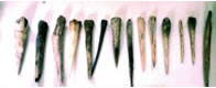
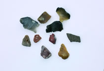
The earliest settlers of Orkney could have been seaborne and may be from Britain, Ireland, Denmark or Norway. The settlement nearest to Orkney was in the Caithness. It was said that these people moved around with vessels of light wooden keel and frames that support the woven framework of withies covered with stitched tanned leather hides. Orkney has small stone objects found on a ploughed field, described as “microliths” due to their small size yet carefully made flint tools (below). These microliths are said to resemble microliths of Scandinavian and Scottish finds. It was also said that many were mounted on wood to make knives, scrapers, arrowheads, harpoons and other useful things (Lacaille, 1935). These Mesolithic stone artefacts were found in several locations in Orkney.
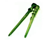
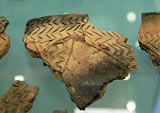
Ritchie suggested that “… flintwork that looks Mesolithic can turn up on Neolithic sites… where it is more likely to indicate the survival of old fashioned ideas in toolkits than pre-Neolithic activity” (Ritchie, 1995, p 20), but Renfrew (2000) contests the idea of permanent Mesolithic settlement in Orkney. Fildlay (1997) also pointed out that the flint assemblage from below the chambered tomb at the Point of Cott, Westray, has been linked to the Mesolithic. Nevertheless, other important findings are the Grooved ware sherds (below) that resemble many stone art decorations that would be unearthed later. This era had speculations that ice melted and land sank that lost coastal sites to the sea (Tait, 2006). A re-examination of the lithics from the 1970s excavations at Skara Brae identified two pieces of “Mesolithic Character” representing residual Mesolithic pieces and hinted of a pre-existing Mesolithic site being disturbed by the Neolithic village” (Saville 2000, p s95).
It was further suggested that farming came to Orkney through Caithness during the Neolithic age, which linked culture with Scotland about 6,000 years ago. The Knap of Howar in the island of Papay, dating about 3600 BC, was described to have strong similarities with finds in the North of Scotland. Settlements in Skara Brae in Sandwick, Rinyo on Rousay, Noltland on Westray, Pool of Sanday and Barnhouse in Stenness followed. These were built by accomplished stonemasons that reflect long settlement in the area. It was suggested that Mesolithic tools indicating earlier occupation were found at the lowest levels and probably had Orkney settled much earlier than already established. It has also been suggested that the Neolithic in Orkney is divided into two general phases, an early and a late, each characterised by different styles of decorated pottery and architecture. An overlap between the two phases and the transition period was said to have occurred around 3000 BC (Renfrew 1979, pp199-212).
Other artefacts (Appendix a and b) were found, which include bone tools and large whalebone pins from Skara Brae. The houses were described as sophisticated and built with double-skinned drystone walls, packed between and surrounded on the outside with midden but unlike similar stone houses in Britain or even Europe (Tait 2006). Interesting features of unknown origin are the strong resemblance in shape and internal features with some of the early chambered cairns, with distinctly boat-shaped outlines (Appendix c). Neolithic houses, as exemplified by those found in Skara Brae, have a much more squared shape, with built-in bed spaces resembling the later Maeshowe-type tombs (Tait 2006).
Downes et al. (2005) suggested that the investigations of Orcadian burial mounds and “tumuli” in the 19th century has focused mainly on the Neolithic and Iron Age and tended to ignore the preceding period as well as the intervening Bronze Age. The apparent lack of evidence was, in part, the reason.
The huge legacy of known archaeological finds has not deterred Orkney from surprising academics and laypeople with the various new sites still being discovered in the islands. 1998 saw the first undisturbed chambered tomb discovered in Orkney at Crantit (Ballin and Smith, 1999). Excavations of the Iron Age ‘ritual complex’ at the Maineshowe (Card et al. 2000), and the mortuary structure and cemetery at the Knowe of Skea, Westray (Moore and Wilson 2003), have added interest in the Iron Age.
Statistical analysis by David Fraser (1983) supports a possible typological division between the Orkney-Cromarty cairns and the Maeshowe group. However, some tombs exhibiting features from both styles of architecture and the important results of excavations at the Point of Cott (Barber 1997) make the suggestion questionable.
Architecture is also mirrored in the domestic sphere through the organisation of space within the early Neolithic houses of the Knap of Howar, Howe (Ballin Smith (ed) 1994, pp 10-13) and Stonehall. The Orkney-Cromarty tombs had chambers subdivided by upright slabs, while the layout by Maeshowe-type tombs finds parallels in Grooved Ware settlements such as Skara Brae (Richards 1991).
Evidenced of development in later Neolithic age was the subtle changes in house design (Richards 1996, p199) applied and the construction of large ceremonial sites exemplified by the Ring of Brodgar, Structure 8 at Barnhouse (Richards forth), Maeshowe and Structure 8 at Pool (Hunter 2000, pp121-122).
Examples of Rock Art at Orkney
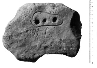
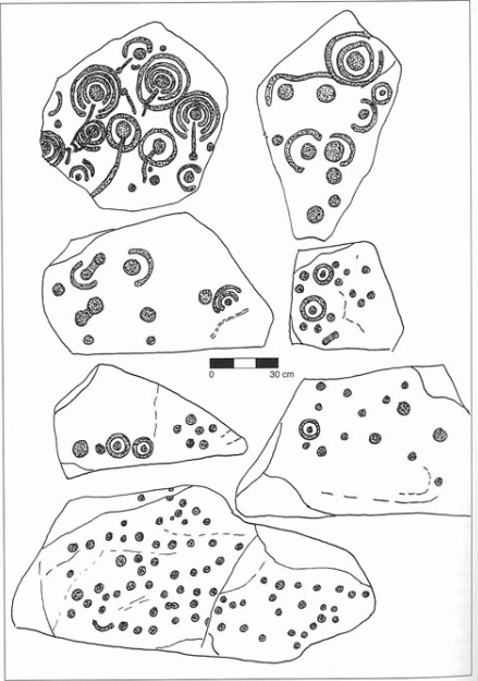
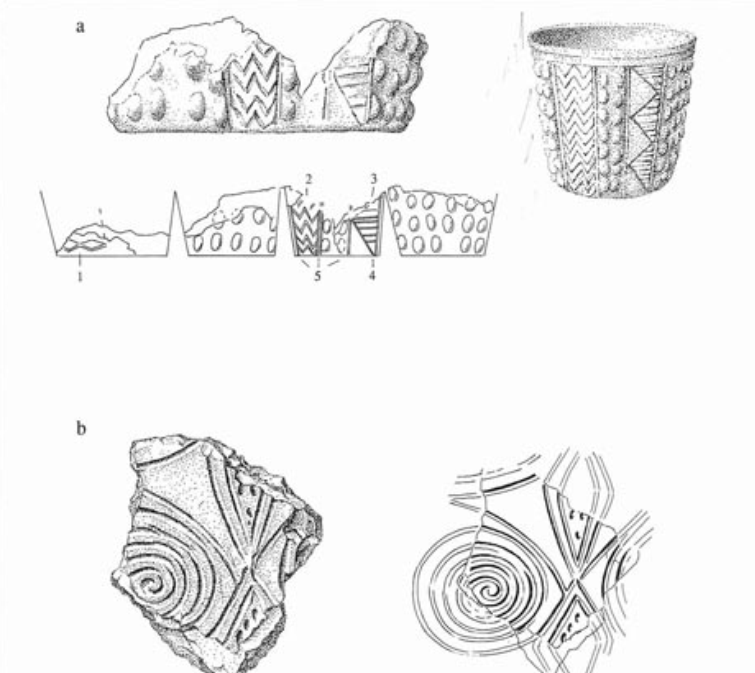
There are cited examples of decorated rock in Orkney, as discussed by Beckensall (1999), claiming a heavy concentration of prehistoric monuments, specifically with 11 decorated slabs. He found the block from Westray as superbly made, which was found during quarrying behind the bay of Picrowall. Flint-working platforms were built on the demolished chambered tomb apparently made by the Grooved-ware users in the later Neolithic age. The marked stone may have come from a tomb about 18 meters or 59 feet in diameter, which may have been a lintel. Two other stones from the quarry had pecked linked spirals.
The stone in Tankerness House Museum, Kirkwall, is the largest, which showed pecking and smoothing techniques. The stones were described as having concentric circles around a central cup from Picaquoy, another with a series of double circles and double volutes from Eday, and the elongated one from Frith has a volute cut on end (Beckensall, 1999).
One of the best-preserved Neolithic villages – Skara Brae – has a potsherd with spirals and lozenges motifs, while other low-key decorations include incised rather than picked with parallel lines triangular lozenge shapes and chevrons. Some of these were found in Maeshaowe, at the Holm of Papa Westray tomb, and houses such as in Skara Brae found in the midden, passage walls, and inside two houses.
As early as 1925, the area close to Brodgar farm had excavations of six cists associated with a slab that bore eight bands of incised decoration. With these were uncremated bones.
The Barnhouse settlement excavated near the Stones of Stennes had rocks scratched with parallel lines, chevrons and hatchings. Structured designs were also found on a slab at the Ness of Brodgar with eight parallel tubes filled with oblique parallel lines, chevrons, lozenges and hatchings. Beckensall (1999) proposed that the awareness proved that Neolithic art was not limited to curvilinear designs. It also suggests that similar types of art or decoration may have been used in other perishable materials.
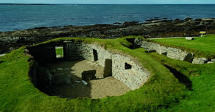
The Unstan or Onston cairn that sits on a small grassy promontory jutting out into the salty water of the Stenness loch could have visitors view the Ring of Brodgar and Salt Knowe across the loch to the north-east, as well as the Deepdale monolith, is silhouetted against the western horizon. Seen from the outside, the structure is comparable to a smaller version of Maeshowe as another grassy mound. But inside, the architecture is distinct from Orkney’s Maeshowe-type tombs, although sharing some elements. Inside has human and animal bones and a large quantity of pottery scattered across the floor of the tomb. The fragments were said to have come from at least 30 Neolithic bowls, with distinct shapes and decorations identical to that found at the Knap of Howar on Papay. The large quantity of the Neolithic bowls found led to the specific style being named after the tomb — the Unstan Ware described as round-bottomed with linear decoration below the rim (Towrie, 1996).
Here, decorative incised markings were found resembling wicker baskets and the designs on pot rims. The sherds of pots varied from tiny to over 60cm in diameter, and two different types of pottery artefacts were found in these Neolithic sites with similarities between pottery and other artefacts found in Portugal, southern England, and Ireland. This suggests that there were contacts with people in these areas to the Neolithic Orkney settlers.
The Temple Wood stone circle, along with other sites, have a variety of motifs with simple cup marks, complex spirals, and flat pitted axes provide a glimpse that motifs were used for long periods. Beckensall (1999) noted that while landscape rock art is meant to be seen, the ones in burial are not, which may convey a difference in perception of how it should be used. It was also perceived as earth oriented as opposed to those that look up at the sky.
The Nether Largie North cairn was described as a possible standing stone with two distinct motifs of cups done with very fine stone pick and axes of metal. Some pecked with a blunt pick, and others chiselled with a metal tool.
The LHS is smoothed and may have been the portion slotted to the ground, while the rest has clear clusters of small pick marks. Broken at the RHS top corner, a cup mark is pecked on the surface and may have been removed from its socket while the axe heads were added when the slab became a cist cover. A few of the axes were unfinished and faint, while an end slab had large and small axe built into the cist with the decorated surfaces facing inwards (Beckensall, 1999).
Kilmartin has remarkable and quality rock art in its burials and ritual monuments, also noted for placement of motif in the landscape. The area has been said to be an important through-route from the sea, and access to land gave its economic and ritual importance. Its low land covered with peat was able to preserve monuments that peat cutters exposed (Beckensall, 1999). The motifs are said to occupy a significant place in the landscape, basically to mark the site that gave access to the large plain. Outcrop rocks are almost unnoticed: near-horizontal and need to be seen closer but form a base for a rich variety of motifs (Beckensall, 1999). These are sedimentary sandstones, shale and limestone metamorphosed by heat and pressure of the earth movements that turned them quartzite, schist, or marble. The movements of ice sheets southward left boulder clay and raised beaches where it is believed that 5,000-year-old cups and rings were formed in the peat. Beckensall (1999) also noted that there had been about 200 years of peat digging for the exposure of these monuments.
North of Kilmartin, in Creagantairbh, an exposed rock sheet marked by an erratic boulder with over 130 cups and 12 cups with single rings described as mostly fairly simple. The north end has an oval with a cup, a series of small enclosures which are quite unusual, with a long groove leading along the rock to its northern extremity (Beckensall, 1999).
Argyll also provides concentrations of rock art from simple to complex motifs on boulders.
Cup Marked Stone
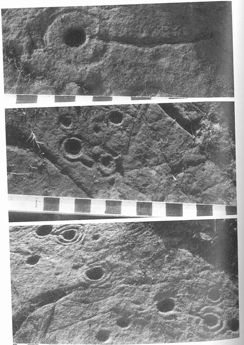
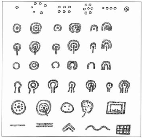
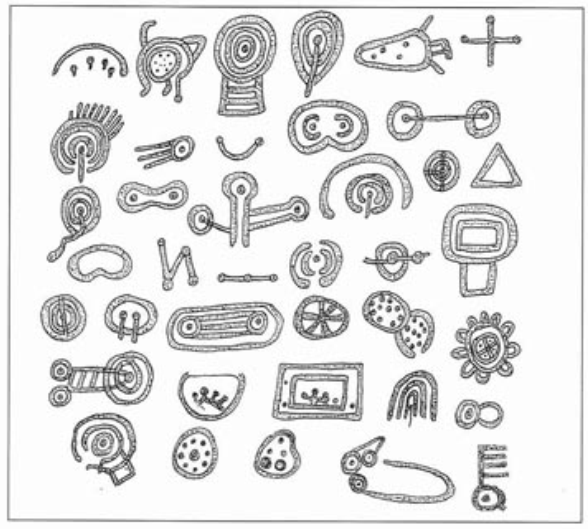
Decoration for cup-marked stone consist of a concave depression about a few centimetres across pecked into a rock surface, and may be surrounded by concentric circles also etched into the stone. Cup marks or cup and ring or cup and partial ring are said to be the most frequent motif that tends to occur near places where copper or gold ores were mined, further suggesting priestly-prospector’s map or signpost use (Weir, 1980). For Beckensall (1999), cups are the most common symbols and may appear singly, randomly clustered, in domino patterns, a rosette, in a straight of a curved line, as well as countersunk. Others seen in Orkney are cups at the centre of curved grooves described as cup and ring, cup and multiple rings, cup and penannular, cup and multi-penannular, cup and arc or semi-ovoid, and cup and multiple arcs. In addition to these are also cups with grooves running from them which may also be called gutters, and findings include cup with groove cutting through the ring, cup with groove cutting through multiple rings, cup and groove with penannular, cup and groove with multiple penannular, cup and groove with arc, and cup and groove with multiple arcs.
Cup-marks, most of the time, resemble those natural cup-marks that have evolved from natural solution-pits. Few of these have a linear channel or a gutter that leads out from the middle (Rachelle, 1999). Aside from the rocks or stones of Orkney, other findings for cup or ring decorations are at:
- Chatton Sandyford cairn and Fowberry petroglyphs in Northumberland
- Backstone Beck petroglyphs on Ilkley Moor
- Bachwen portal dolmen in North Wales
- Dalladies long barrow, Kincardineshire
- Street House cairn in Cleveland
- Dalgarven Mill, North Ayrshire
- Mauchline Gorge, East Ayrshire
- Brodick, Isle of Arran
- Blackshaw Hill, North Ayrshire
- Kilmartin, Argyll
- Achnabreck, Argyll (Beckensall, 2002).
The cup mark decoration is considered a petroglyph on natural boulders and outcrops also identified with megalithic art on purposely worked megaliths such as the slab cists of the Food Vessel culture, some stone circles and passage graves such as the clava tombs and on the capstones. While these are etched on a natural, flat stone, they are sometimes incorporated in the natural surface of the rock and seen along shores or elevated areas that command an extensive view of the lower ground. They had also been associated with natural stone outcrops exploited by Neolithic peoples to make polished stone axes, and religious purpose has also been suggested (Rachelle, 1999).
As for Grooves enclosing multiple cups, these may be illustrated and described as: a rosette enclosed by a ring, a rosette enclosed by two concentric rings with the central cup having a groove that cuts the ring, an oval groove enclosing cups, a heart-shaped groove containing cups, some connected, and one with a groove leading out, as well as multiple rectangular grooves enclosing cups.
McMann (1980) argued that distinctions made between passages graves and the variety of cup and ring forms on free-standing boulders or rock surfaces may be practical for organisation purposes but challenging to maintain. One instance is the passage-grave symbols on outcrops of rock independent of any structure as against the Irish passage graves with cups and rings. Cup and ring sites, however, may be plausible. Cup marks are found on standing stones, vertical surfaces, and on horizontal surfaces. In addition to the above descriptions, cup marks are found to be map-like patterns of circles, rounded rectangles and dots that may occur isolated or as part of an extensive concentration on large outcrops or other rock surfaces (McMann, 1980). These were seen generally as lacking formal organisation as compared to other passage graves as there is minimal concern for the form of the rock no matter how skillfully and accurately pecked. Likewise, there is also the perceived lack of relations of one symbol to another is irregular and done haphazardly. In contrast to passage-grave builders, they were particular to achieving a particular symbol through fine execution as well as minding the relationship of one symbol towards other symbols present to achieve a complete design. It was, however, noted by Evan Hadingham that simple cup marks are the oldest and most repeated motif in British rock art dating those at chambered tombs as ca 4000 to 2000 BC, those on standing rocks and stone circles ca 2500-1200 BC and on stones in single graves ca 2000-1400 BC. In addition, techniques were identified as striking of flint or quartz points with a wooden mallet as supported by a finding in Italy of quartz tools (McMann, 1980).
Preliminary planning is also apparently absent as compared to passage-graves, as lightly picked designs were used as a guide for subsequent elaboration. Refinement through light picking, use of false relief or picking away the surrounding area of a design, as well as area picking on the design itself and inscribing in an area already recessed through picking. In describing the cups and rings found at Achnabreck, Argyll, Scotland, the three large sheets of rock had some of the cups and rings with comet-like tails and clustered in random on the outcrops that are et in the pine woods viewing the Kilmartin Valley (McMann, 1980).
Ring or Concentric rings
This decoration is more or less related to cup marks and ring design in stone art, as mentioned earlier. A concentration and series of out-rings come after the other. Cup mark and concentric ring, as well as the concentric lozenges, are frequently used in passage tombs. These are usually used in lower surfaces of the covers of kist-tombs believed for funerary use (Weir, 1980).
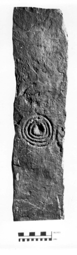
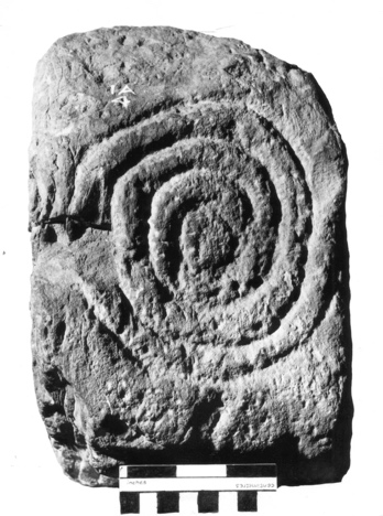
Beckensall (1999) described the stone or rock sketches for rings, penannular and arcs as any of the following: ring, concentric rings, penannular or gapped rings, multiple penannular, arc, or multiple arcs. Likewise, for Beckensall (1999), a circle is a symbol of great importance with meanings that are more complex than what archaeologists will ever know.
McMann (1980) noted findings of patterns of circles, rounded rectangles and dots in isolation or as part of an extensive concentration on large outcrops and associated rock surfaces as lacking formal design. In particular, there is the description of finds at Kilmichael Glassary of an outcrop fenced off across the road with “interesting keyhole patterns, quite weathered…” (p 89).
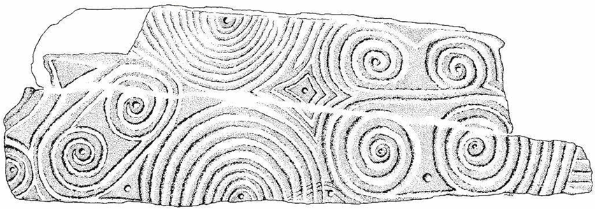
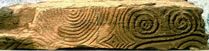
Spiral Stone
Spirals, according to Beckensall (1999), have a special and distinct place among the motifs and are sometimes linked directly to cups and rings. Some hybrid spirals have incomplete patterns of motifs that are incomplete or badly executed, although acceptable under this category. Considered as one of the best-made spirals are found in Passage Grave art in Ireland that is directly linked with England, Wales and Scotland, such as the British site at Morwick in Northumberland. Spirals are represented in horned spirals, triple linked spirals, and others. Their location, according to Beckensall (1999), needs the use of a ladder as these spirals were chipped into rocks at high points. Northumberland has two sites with spirals: Lilburn, where a pillar-like rock horned with spirals and concentric circles was found in a pit with layered cremation burials, and a spiral on an outcrop at Horton with the pit burial identified to be Neolithic (Beckensall, 1999).
Another spiral was found in a probable burial area at Little Meg, of which it was connected to concentric circles. Nearby is another stone circle at Long Meg and her Daughters, where a large outlying sandstone monolith is covered with motifs that include spirals (Beckensall, 1999).
At Old Park, a plundered mound, a row of upright stones had simple “shepherd’ crooks” spirals described with unfolding curves that turn to the right and left individually. This is also believed as a related burial site. Another spiral was seen at the Castlerigg stone circle located at the end of the box-like setting of stones that intersects a circle and facing inwards (Beckensall, 1999, p 15).
Spirals were also found in Hawthorne near Edinburgh, located in a vertical cliff face. The spirals are interlocking, formed a single groove that left two spirals in relief instead of being recessed (Beckensall, 1999).
Grooves
Grooves may enclose multiple cups and are described as linear, parallel, chevron, serpentine, or grid/hatchings (Beckensall, 1999). Simple grooves in the Orcadian rock art in combination with single or multiple cordons, combinations of cordons and incised cordons produce lozenge and triangle-based motifs incised in stones. Incised Groove Ware motifs is a product of early village excavations expanded by the more recently observed elements on the elaborate base unifying ceramic design with the carved stones (Ritchie, 2000).
Key elements include linked horizontal lozenges seen on landscape stones; zigzag seen on the ground-edge knife at Skara Brae; horizontal lines of banding found on rock slabs; vertical triangle present on loose stones from Passage A; and vertical lines that separate bands of decoration seen on Hut 8 stone (Ritchie, 2000). The Skara Brae designs are representative of Grooved Ware motifs.
Incised rock art
Incised rock art is a technique used to decorate stone surfaces where a channel is scratched in the stone, then a thick paint or stucco plaster is laid across the surface prior to scraping off the surface of the stone to leave the paint incised.
Other Designs
Forms of lozenges, chevron and simple cross-lozenge show continuation and development of rock art motifs but with haphazard distribution across one slab. These are exemplified by finds at Passage A, of which adaptation appeared in House 2, Phase 2 at Balfour Stewart’s 1913 excavation. The design of a band of cross-hatched net motifs attached to lozenge and chevron or triangle form echoes the design of a 3-spiked object in loose context (Ritchie, 2000).
Conclusion
With the above discussion, there definitely is the presence of rock art in prehistoric Orkney, but which seem to follow the proposition of various research, archaeological findings and studies linking its early settlers to inhabitants of other points of Europe such as mainland Britain, Spain, Ireland, and even those in Italy. Likewise, chamber rock art in Orkney’s burial chambers also suggests similarities to inscriptions often found in other chambers around the U.K. and Ireland, so that it cannot be said for certain that the examples of rock art in Orkney are unique to the isles. There is either certain mobility that allowed such distribution of rock art motifs in various spots of Europe or even Asia and other regions if it cannot be said that the settlers of Orkney had prehistoric contacts with their counterparts in those mentioned areas.
Reference
Ashmore, P.J. (1996). Neolithic Bronze Age Scotland. BP Batsford Ltd., England.
Beckensall, Stan (2001). Prehistoric Rock Art in Northumberland. Tempus Publishing.
Beckensall, Stan (1999). British Prehistoric Rock Art. Tempust Publishing LTD. Gloucestershire.
Butter, Rachel. 1999. Kilmartin. Kilmartin House Trust.
Downes, Jane, Sally Firester and C.R. Wickham Jones with Jude Callister (2005). Historic Scotland. Edinburgh.
Díaz-Andreu, Margarita, Christopher Brooke, Michael Rainsbury, Nick Rosser (2006). “The spiral that vanished: the application of non-contact recording techniques to an elusive rock art motif at Castlerigg stone circle in Cumbria.” Journal of Archaeological Science, Volume 33, Issue 11, Pages 1580-1587.
McMann, Jean (1980) Riddles of the Stone Age. Thames and Hudson Ltd.
Richie, U. (2000). “Neolithic Orkney in its European Context.” McDonald Institue for Archaeological Research-Cambridge. Shepherd, Alexandra.
Tait, Charles (2006). Orkney Guide Book, Web.
Towrie, Sigurd (2008). “Orkney Archaeology News.” Orkney Jar, Web.
Towrie, Sigurd (1996). “A Brief History of Orkney.” Orkney Jar. Web.
Weir, Anthony (1980). Early Ireland: A Field Guide. Web.
Appendix