- Name: Lesson plan for Social Studies.
- WGU Task Objective Number: 602419-08.
General Information
- Lesson Title & Subject(s): Social Studies.
- Topic: Map Skills (Measuring Distance and identifying physical features).
- Unit of Study: Distance: Calculation of distance on maps.
- Grade/Level: Fourth grade.
Instructional Setting
Fourth-grade classroom: this class contains 28 students, there are roughly 13 boys and 15 girls, always seated on desks during the lesson. Students will be sitting at their desks arranged four rows parallel to each other, consisting of seven desks in each respective row. The main purpose of sitting on desks during the lesson will be predominantly for the presentation of new information and thereafter, the arrangement of the desks will change for predetermined pairs for guided practice during the group discussions. In most of the teaching moment, students will be seating on desks as the teacher explains and demonstrates the teaching concepts for the lesson.
Instructional teaching instruments will be available for students to use. During the lesson, students will possess instructional learning resources including ruling material including meter/centimeter ruler, strings, paper strips, pencils and/or crayons, drawing books, painting materials, wall charts, bulletin boards, and posters, which will provide relevant information pertinent to the theme of distance and measurement.
Standards, Goals, and Objectives
Your State Core Curriculum/Student Achievement Standard(s):
Social Studies Standards (Content subject 1)
National Standards
‘Students in Wisconsin will learn about geography through the study of the relationships among people, places, and environments.’ As stated in the standards, students gain geographical perceptions about the world by studying the existing interaction between the earth and the people concerning their living zones and their activities.
General Lesson Goal(s):
At the end of the lesson:
Lesson goal 1
Students will be able to understand how to estimate measurements and calculate short distances provided in a given map using simple measurement units like centimeters, meters, and Kilometers.
Lesson Objective(s): (For Social Studies)
- Competency goal 1: At the end of the lesson, all students participating in the lesson must be able to understand terminologies used in distance measurement (I.e. centimeter, meter, kilometer).
- Competency goal 2: By the end of the lesson, the learner should be able to correlate between the drawing distance and real distance.
- Competency goal 3: At the end of the lesson, learners must be in a position to understand how the theme of measurements correlates with real-life practices.
- Measurable goal: Given the 10 assessment questions meant for formative assessment, students should be able to score at least 8/10 on average.
Lesson Objective(s): (For Mathematics)
- Competency goal 1: By the end of the lesson, students should be able to understand how to apply simple measuring units and their initials.
- Competency goal 2: By the end of the lesson, learners will have developed simple measuring techniques used in determining distance on a given worksheet.
- Competency goal 3: Before the lesson end, all students participating in the class teaching will be well acquainted with the skill used in converting measurements.
- Measurable goal: Given the units in the assessment measurement table or matching sheet, learners should manage to score at least 85% in the matching test.
Lesson Objective(s): (For English)
- Competency goal 1: Before the lesson end, students must be in a position to understand the terminologies taught and use them correctly.
- Competency goal 2: At the lesson end, learners should be able to read the vocabulary correctly and fluently following verbal rules like pronunciation.
Materials and Resources
Instructional Materials
During the lesson, the students will be using several instructional materials including meter or centimeter rulers, strings, paper strips, pencils and/or crayons, drawing books, calculation notebooks, painting materials, wall charts, bulletin boards, and posters.
Primary Resources used
Borich, G. (2010). Effective teaching methods: Research-based practice (7th Ed.). Boston, MA: Prentice-Hall. ISBN: 0131367188 or 978- 0131367180
Duplass, J. A. (2011). Teaching Elementary Social Studies: Strategies, Standards, and Internet Resources (3rd Ed.). Belmont, MA: Wadsworth, ISBN 10:1111179352.
Chapin, J. R. (2006). Elementary social studies: A practical guide (6th ed.). Boston, MA: Pearson Publishers. ISBN 13: 9781111179359.
Instructional Plan
The sequence of Instructional Procedures/Activities/Events (provide a description and indicate the approximate time for each):
Identification of Student Prerequisite Knowledge and/or Skills: (3 minutes)
Identification of prerequisite student’s knowledge will be necessary to enable the teacher to gauge student’s current level of knowledge on the topic and provide a possible gateway to the Sequence of Instructional Procedures, which will form part of the pre-assessment plan.
Review of previous definitions of terms and concepts
The subject teacher will begin the lesson by reviewing previous definitions of terms and concepts as an introductory strategy for the lesson. For instance, under social studies, students must possess knowledge of what the topic entails. For example, distance is a physical length or a numerical description of how far apart objects are.
Linking the topic to previous learning
The teacher will then connect the intended topic with previous teachings to access the level of knowledge embedded in each student. The teacher will ask oral questions about the topic or provide a simple statement. For example, there are several units of measurement used to calculate short distances in plain sheets. The teacher will then allow students to provide exemplars of units (e.g. meters).
Presentation of New Information or Skills To Be Taught (5 minutes)
The subject teacher will provide a concrete introduction to the new information starting with the main objective of the study.
Theme
Today we will be studying measurement: Calculation of distance using simple material.
Distance
- Distance is the physical length from one place to another.
- Distance is measured using mathematical units (e.g. meters, centimeters)
- Unit shot forms representing meters is m, centimeter cm, and kilometer km.
- We can measure distance vertically or horizontally depending on the place.
Map
- A map is a diagrammatic representation of an area of land or sea on a piece of paper.
- The map can contain physical features like hills, mountains, valleys among others.
- Other important features on maps include roads, railways, and pathways, among others.
- We can measure roads or railways on a map using rulers, strings, paper strips in simple measuring units like meters, and centimeters.
- Maps usually have a representation scale that learners can use to convert the measurement units.
Meter/ Centimeter Ruler
- A meter or centimeter ruler is a small measuring device used by learners to measure short distances on flat surfaces, i.e. on books, maps, and sketches.
- A ruler has measurements in units of meters with initial m and centimeter cm.
Modeling: I Do (5 minutes)
After Identification of prerequisite student’s knowledge, the lesson will begin officially. During the lesson proceeds, I will be standing in front of the classroom, demonstrating and delivering the teaching concepts to the students to provide the necessary connection between concepts and prior conclusions.
- Using the whiteboard or blackboard, whichever will be available, I will be explaining the concepts and themes while demonstrating using the necessary instructional material. I will start by writing the theme of the lesson, which is the topic. Using all the whiteboard/blackboard rules, I will frame the writings in the desired style. Let students understand that a measuring stick or a ruler shows the relationship between distance on the map and distance on the earth.
- Using my wall map as instructional material, I will pin the wall map on the white board to allow students to have visual access to the concepts. In simple terms, I will define a map and its intended use in the underway topic. For instance, a map is a diagram showing a piece of land or sea on a small flat surface, especially on papers. It possesses physical features that we can measure using strings or rulers.
- I will instruct students to show their rulers and all measuring instruments, to confirm that all students possess the right instructional material. Using my meter stick or popularly known as black/whiteboard ruler, measuring stick one meter long, I will select two roads or railways (a straight one, and a wavy one) and mark the distances as students watch. I will try measuring the two using a meter stick. I will ensure that students maintain silence and follow the procedures as I demonstrate.
- It will be difficult to estimate the distance in the wavy road or railway. Then I will explain to the students that it is intricate to measure wavy roads or railway lines using a simple meter stick or rulers. Measure the same feature using alternative instructional material including the strings and paper strips. You will realize that strings will manage to measure the two features. I will then explain the reason behind such circumstances.
- Using the provided scale on the map, I will explain to the students the need to have the scale, providing necessary conversion calculations either from the meter to centimeter, centimeter to a kilometer, and from meters to kilometers. I will let the students understand that 1 km equals to 1000m, 1m equals 100cm, and so forth. Allow them to convert simple figures.
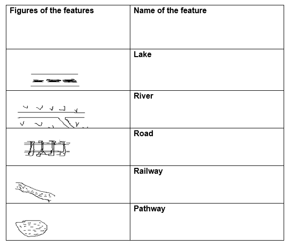
- I will demonstrate the representative symbols used to represent features on maps and sketches, especially the roads, railways, rivers, lakes, and the pathways that one can manage to measure their distance in terms of length, square, and perimeter or boundary. I will ensure that these symbols reflect the real representation of the features on the land.
Guided Practice: We do (10 minutes)
- The teacher will arrange the students in groups of sevens to form four corroborative learning groups. Each student will possess individual learning instructional materials including strings, paper strips, and a sample of a map. Students will now be engaging in interactive learning with the teacher. This section will from the formative assessment.
- Identify I feature that students can locate in their maps that resemble the feature in your wall map. Ensure that there is maximum silence and highest concentration on the board as all students face the teacher. Explain and demonstrate how learners should measure physical features given the map or any diagram representing the feature. Using the strips and stings, measure the feature accurately and correctly and instruct students to practice the same in their maps.
- Instruct the students to identify measurable physical features on the map including the roads, railways, rivers, lakes, and the pathways that one can manage to measure their distance in terms of length, square, and perimeter or boundary. Following the procedures used in measuring the length and perimeter, allow them to carry out interactive learning by identifying features and measuring them.
- In the meantime, students should be writing necessary measurements in their notebooks, ensuring that there is the correct spelling of the newly introduced vocabulary in the lesson. Students must integrate the measurement symbols of meters, centimeters, and kilometers coherently as they commence with the activities. Mark the group work where appropriate.
Independent Student Practice: Students Do (10 minutes)
After interactive group discussion work, students will manage to resume their sitting positions for a predetermined teaching procedure. The teacher will provide students with individual assessment tests to examine the level of knowledge acquainted during the teachings, which will also be part of the formative assessment employed by the teacher.
Assessing Social Studies
- For social studies as the teaching content subject 1, Issue out a matching sheet containing respective physical features to each of the individual students.
- Provide instructions that will provide guidance and govern the assessment. For instance, let the students understand that they will be matching the features with their respective names.
- Let them understand that only free drawn lines will be useful in establishing the connection between the physical feature and its descriptive name.
Match the feature with its name
Assessing mathematics
- For mathematics, as the second teaching content subject, the teacher will issue a table consisting of measuring units for students to convert the units.
- The teacher will let students understand that they will only use arithmetic symbols taught in the discussion. I.e. use only m, cm, or km.
- The teacher will let the student understand that the assessment will be an individual practice and that students should not discuss or copy.
Complete the conversion table.
Culminating or Closing Procedure/Activity/Event: (10 minutes)
Ensure that students have delivered assessment papers for both social studies (Content subject1) and mathematics (Content subject 2). It is necessary to make a comeback to the concepts and themes to ensure that students have achieved the learning goals as indicated.
- The teacher will write all the vocabulary used in the topic on the white/blackboard. Thereafter, each student will have an equal chance to explain the geographical meaning of the words (Chapin, 2006).
- The teacher will in the shortest time possible draw the two tables used in the formative assessment on the black/whiteboard for students to view.
- The teacher will display the map again and allow students to engage in a classroom activity that will ensure all students have received the concepts thought.
- The teacher will revise the assignment as students engage in interactive learning comparing physical features from the map to the ones drawn on the black/whiteboard.
The teacher will then use the available classroom computer and a Digital screen display to integrate technology in the lesson. The large digital screen and a recorded DVD will be useful to show the teachers how they can use digital libraries as learning resources to find appropriate information. Using Google search techniques the teacher will search for online maps comprising of all symbols discussed in the lesson, the photos will then project on the large digital screen to provide a wider display. The teacher can then as simple questions and finally show some of the features that will form the next lesson as a way of connecting students to the next lesson.
Pedagogical Strategy (or Strategies)
During the teaching activity, the teacher will employ different pedagogical strategies as part of instruction procedures. The teacher will employ a direct instructional approach, cooperative and interactive learning groups, and partner work as well. The direct instructional approach involved issuing instructions to students while undertaking classroom activities during the teaching period. Students also engaged in-group discussions on how to measure distances of simple physical features using strings, strips, and rulers. The teacher also employed the partner work strategies where students sat in groups of threes as in the case of their normal sitting as the teacher issued discussion assignments at the end of the lesson.
Differentiated Instruction
As the class composed of students with different ability levels, the teacher will employ differentiated instruction. The class had no disabled individuals and only the intelligent and the dull students interacted in groups developed during the lesson. Students with greater intellectual ability engaged in collaborative learning with the dull students were during the group discussion, at least there was a mixture of abilities and talents that allowed interactive learning (Hargreaves, 2000).
During the lesson, students with greater intelligence assisted others to cope with the learning procedures by assisting them to understand the concepts, themes, and terms employed in the study. The teacher provided flashcards for students to join while trying to understand the meaning and writing of the newly introduced vocabulary.
Technology Integration
The teacher will use the available classroom computer and a Digital screen display to integrate technology into the lesson. The large digital screen and a recorded DVD will be useful to show the teachers how they can use digital libraries as learning resources to find appropriate information. Using Google search techniques the teacher will search for online maps comprising of all symbols discussed in the lesson, the photos will then project on the large digital screen to provide a wider display. The teacher can then as simple questions and finally show some of the features that will form the next lesson as a way of connecting students to the next lesson. Digital flashcards will also form part of learning for students to understand the terms and enable them to use them grammatically correct.
Student Assessment/Rubrics
- Pre-assessment plan- for establishing if students’ achieved prior teachings and if they have, any idea of the topic projected for discussion, the teacher will undertake pre-assessment. For the pre-assessment examination, the teacher will introduce the topic with some verbal questions to bring students into attention and test the level of prerequisite knowledge. The pre-assessment plans will also involve providing students with a simple agree or disagree verbal quiz about the topic that the teacher intends to introduce. The teacher will use all the teaching aids including maps, and learning instruments like rulers, strips, and strings for students to describe and distinguish. The teacher will further develop simple sketches of physical features on the whiteboard as seen on a map for students to identify, as the teacher provides correct answers for them.
- Formative Assessment: To ensure proper achievement of both personal and lesson objectives it will be essential to undertake formative assessment. During the teaching proceedings, the teacher will make sure of the use of consistent questioning and simple testing to ascertain the level of understanding. After delivering all concepts and discussion of the themes in the subject, the teacher assesses students’ understanding using a matching worksheet and conversion table in which each student will try to match features with the respective geographical names and provide accurate conversion for the measuring units. After successful matching in the matching sheet, this aspect does not guarantee the total achievement of the concept. Under any circumstance, each student must score at least 90% in the matching sheet and score at least 8/10 in the conversion table.
- Summative Assessments: This will include techniques indispensable in evaluating the whole learning process and the development of learner’s knowledge in succeeding lessons. For this study, a cumulative assessment will involve consecutive assessment where each consecutive day, throughout the first four minutes, the teacher will engage in a slight discussion with the class to assess the previous knowledge and connect it to the predetermined lesson (Duplass, 2011). A comprehensive assessment will engross reviewing unit tests, performance tasks, and individual portfolio review for each student. Students undertaking these tests during the cumulative assessment must attain about a maximum mean of 80% as a pass mark throughout succeeding periods of tests. On weekends, the teacher will provide students with several assignments on the discussed concepts and themes to undertake. The school will supply continuous assessment tests as slated in school routines.
Importance of Effective Collaboration
Just like in a profit organization where cooperation and teamwork determine the outcome, collaboration in the teaching profession is also important. Generally, positive results in many schools result from the teacher, parent, and student collaborative efforts. However, in the teaching and learning process, teacher-teacher associations greatly influence students’ performance. Student academic performance depends on teachers’ levels of commitment and cooperation. Teachers often collaborate in teaching through teamwork meetings, lesson studies, and friendship groups, during which teachers undertake effective planning, crucial observations and analyze class or school performance. All these activities principally focus on supporting student development, learning, and well-being.
Insights from Observed Video
The video comprises two participants sitting adjacent to each other. Most probably, the theme is about social studies lesson planning. Based on video simulation produced on the subject of effective teacher collaboration, several observations appear apparent to teacher collaboration and cooperation. The video replication entails a collaborative process between the student on the Pre-clinical Experience assessment and the teacher (or the specific school staff member) responsible for supervising the Pre-Experience assessment.
The supervisor keenly questions the students on what the lesson plan lacks and what they should add to make the lesson plan improve. During the collaboration process, the two members notice the omission of important aspects of inclusion like social studies teaching standards and objectives. They noticed that students have been lesson planning, but meeting very few social studies standards. They reviewed through files to confirm the right way to correct the lesson plan including necessary social studies standards.
Analysis of Collaborative Process
The video simulation entails a collaborative teaching process. As postulated before, during the collaboration process, the two featured teachers notice the omission of important aspects of inclusion like social studies teaching standards and objectives. They noticed that students have been lesson planning, but meeting very few social studies standards. They reviewed through files to confirm the right way to correct the lesson plan including necessary social studies standards.
Typically, the collaborative discussion involved several collaborative measures including searching for relevant references from primary sources that enabled them to conclude the areas that the previous lesson planning omitted. Borich (2010) affirms that lesson plans must include all components. The collaborative process allowed the featured student to have a greater understanding of lesson planning.
Impact on the teaching Strategies and Instruction
As observed in the simulation, the two teachers revised the lesson plan. After revising the lesson plan, they concluded. The revised lesson plan enabled the teachers to have greater teaching confidence as the themes, concepts, terminologies, and procedures including appropriateness of hands-on activities improved. They ensured that the revised lesson plan included all the basic social studies standards and the hands-on activities are appropriate. The subsequent lessons taught by these teachers now improved in instructional planning and their objectivity. The influence of the revision and the impact was therefore eminent throughout teaching strategies and the instructional setting as I was able to achieve greater objectivity in the second lesson.
Explanation of the revisions
As per the video, on noticing the mistakes undertaken in the preparation of the initial lesson plan, the two teachers reviewed the necessary components with problems and replaced them. Two major fixes improved lesson planning. The fixes in the initial lesson plan involved determining which standards achievable through the lessons and determining how effective field activities influence learning. The teachers fixed the social studies standards with appropriate mathematics and writing standards to meet the desired plan and ensure that “holidays around the world” allowed children to have different life experiences.
Observation and description
Instructional setting
The level of the class was fourth-grade classroom: the class contained 28 students and there are roughly 13 boys and 15 girls, always seated on desks during the lesson. Each student sits in his/her respective position on a chair supported with desks to write on. The classroom arrangement involves students desks arranged in four rows parallel to each other, with each row having seven seats from front to back of the class. The arrangement of the desks changes for predetermined pairs for guided practice during the group discussions.
Level of student learning
The students in this class have considerable knowledge on all the aspects of education taught in the lesson. All students acquired the appropriate hands-on activities as guided by their teacher. At the end of the lesson, the students could manage reading the map correctly as well as demonstrating the ability in identifying physical features on the maps. At the end of the lesson, learners could manage to measure distance in maps appropriately and calculate the conversions accurately.
Pedagogical Strategy and Theory of Multiple Intelligences
Howard Gardner introduced the theory of Multiple Intelligences that comprehended human intelligence and the education process. The theory states that the intelligence inherent in each human being differs from one person to another and that intelligence characteristics are unique in each person, even in identical twins. The pedagogical strategy employed in this lesson differed distinctively from any other teachers in the school I served. I considered linguistic use and Logical-mathematical as templates in providing instruction to students.
Appropriateness of Hands-On Activity
The hands-on activities employed in this lesson plan enabled the teacher to undertake the instructional planning effectively. In measurement techniques and map reading, distance estimation is a unique topic that engages learners in various mathematical activities. The hands-on activities engaged the students in active learning, with student’s visual ability increasing as the maps and its feature provided a greater insight into the natural environment.
Appropriateness of Primary Resources
The primary sources used by the teacher in the lesson plan seemed appropriate as most of them comprehensively described the lesson-planning process. Several of the primary sources utilized in this process knew Wisconsin standards of lesson planning. The majority of the sources provided a clear description of the deemed importance of lesson planning, providing me with the confidence I needed in them. Almost all the referencing involved the use of these appropriate sources.
Explanation of the Thinking Process
One cannot imagine how a simple thing becomes complex when there is a lack of prior knowledge and experience in the same. During the lesson planning process, I could not manage to admit that I am in a fix. The process involved several discussions with friends and an intensive search of appropriate primary resources to provide possible assistance before settling down to write. Lesson planning is a mind seizing process.
Alternative Approach
Apart from teaching social studies with a combination of mathematics and languages, other alternative combinations can apply. A combination of social studies and sciences can be a suitable alternative approach that can suit social studies lessons. Teaching about plants and habitat is a topic that the two principles can combine in a single lesson and provide a superior outcome in the teaching profession. In social studies, plants form a human environment where plants form vegetation. The two concepts carry similar standards and generally correlate with local and national standards during such combination.
Justification of Recommendations
The combinations of social studies and human sciences have been useful in integrating the learning process in the teaching profession. From the historical point of view, social sciences have always had a good combination with human sciences as several concepts and themes are inherent in both principles. Teachers in lower grades have always combined the two principles to cover some broad topics comprehensively. The objectivity and standards of the two topics are similar and standards in the local and state realm correlate as well.
Personal Meaning and Professional Growth
Lesson planning has and will continue being an imperative activity in the teaching process. Personally, the process has increased my level of understanding of practical teaching experiences within the profession. The process enhanced my teaching methods by understanding the importance of lesson planning, techniques in lesson planning, and important ways of combining two teaching subjects in a single lesson. I now have a broader experience in classroom instructional planning and this will help expertise my experience in the teaching profession. Generally, the process provided a whole growth in my profession.
Reference List
Borich, G. (2010). Effective teaching methods: Research-based practice (7th ed.). Boston, MA: Prentice Hall.
Chapin, J. R. (2006). Elementary social studies: A practical guide (6th ed.). Boston, MA: Pearson Publishers.
Duplass, J. A. (2011). Teaching Elementary Social Studies: Strategies, Standards, and Internet Resources (3rd ed.). Belmont, NY: Wadsworth.
Hargreaves, D. (2000). Four ages of professionalism and professional Learning. Teachers and Teaching: Theory and practice, 6(2), 151-184.